![](/images/other/stat-length.png)
![Tocht Stappen Les Belleville - Le refuge de Gittamelon - Photo](https://media.geolcdn.com/t/1900/400/ext.pjpeg?maxdim=2&url=https%3A%2F%2Fstatic1.geolcdn.com%2Fsiteimages%2Fupload%2Ffiles%2F1553511878bg_sport_marche.png)
Le refuge de Gittamelon
gilsep
Gebruiker
![Lengte](/images/other/stat-length.png)
Lengte
7,3 km
![Max. hoogte](https://static1.geolcdn.com/siteimages/upload/files/1508320355ic_sort_altitude_max_24dp.png)
Max. hoogte
1719 m
![Positief hoogteverschil](https://static1.geolcdn.com/siteimages/upload/files/1508320355ic_sort_den_pos_24dp.png)
Positief hoogteverschil
324 m
![Km-Effort](/images/other/stat-length.png)
Km-Effort
11,6 km
![Min. hoogte](https://static1.geolcdn.com/siteimages/upload/files/1508320355ic_sort_altitude_min_24dp.png)
Min. hoogte
1444 m
![Negatief hoogteverschil](https://static1.geolcdn.com/siteimages/upload/files/1508320355ic_sort_den_neg_24dp.png)
Negatief hoogteverschil
333 m
![Boucle](https://static1.geolcdn.com/siteimages/upload/files/16400158638029165_repeat_loop_refresh_sync_direction_icon.png)
Boucle
Ja
Datum van aanmaak :
2019-01-15 13:28:46.219
Laatste wijziging :
2019-01-15 13:28:46.219
![Stappen](https://static1.geolcdn.com/sitytour/trail-icons/101.png)
2h23
Moeilijkheid : Medium
![Scan deze QR-code om de tocht te openen in de SityTrail-applicatie](https://capi.geolives.com/qq0zvz2zws4bq2lad0pu/sitytour/trails/1009349/qr.png?size=200)
Gratisgps-wandelapplicatie
Over ons
Tocht Stappen van 7,3 km beschikbaar op Auvergne-Rhône-Alpes, Savoie, Les Belleville. Deze tocht wordt voorgesteld door gilsep.
Beschrijving
Laisser la voiture au parking de la Fenêtre (cote 1454). Variante pour le retour par la jolie route qui descend du refuge vers le parking.
Plaatsbepaling
Land:
France
Regio :
Auvergne-Rhône-Alpes
Departement/Provincie :
Savoie
Gemeente :
Les Belleville
Locatie:
Saint-Martin-de-Belleville
Vertrek:(Dec)
Vertrek:(UTM)
302265 ; 5027565 (32T) N.
Opmerkingen
Wandeltochten in de omgeving
![Tocht Stappen Les Belleville - St Martin Belleville-gittamelon - Photo](https://media.geolcdn.com/t/375/260/ext.jpg?maxdim=2&url=https%3A%2F%2Fservices.sitytrail.com%2FGeolivesWS%2FDownloadMedia.ashx%3FTrailID%3D612997%26Media%3D33420aa9-f0ca-4bab-9183-c7bf9f0a6bf0.png)
![Stappen Stappen](https://static1.geolcdn.com/sitytour/trail-icons/101.png)
St Martin Belleville-gittamelon
Stappen
Gemakkelijk
Les Belleville,
Auvergne-Rhône-Alpes,
Savoie,
France
![](/images/other/stat-length.png)
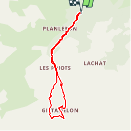
8,2 km | 13,3 km-effort
3h 30min
![](https://static1.geolcdn.com/siteimages/upload/files/16400158638029165_repeat_loop_refresh_sync_direction_icon.png)
Ja
![Tocht Stappen Les Belleville - Montagne de Cherferie - Photo](https://media.geolcdn.com/t/375/260/805b7046-cec6-40c7-9989-cb4bd43bbcff.jpg&format=jpg&maxdim=2)
![Stappen Stappen](https://static1.geolcdn.com/sitytour/trail-icons/101.png)
Montagne de Cherferie
Stappen
Medium
Les Belleville,
Auvergne-Rhône-Alpes,
Savoie,
France
![](/images/other/stat-length.png)
17,4 km | 28 km-effort
5h 42min
![](https://static1.geolcdn.com/siteimages/upload/files/16400158638029165_repeat_loop_refresh_sync_direction_icon.png)
Ja
![Tocht Stappen Les Belleville - Beranger La croix de Jean Les refuges Le col de la lune - Photo](https://media.geolcdn.com/t/375/260/c5ad1e17-310b-48d4-b0e4-7e1619b4b8e6.jpg&format=jpg&maxdim=2)
![Stappen Stappen](https://static1.geolcdn.com/sitytour/trail-icons/101.png)
Beranger La croix de Jean Les refuges Le col de la lune
Stappen
Moeilijk
Les Belleville,
Auvergne-Rhône-Alpes,
Savoie,
France
![](/images/other/stat-length.png)
14,5 km | 25 km-effort
4h 12min
![](https://static1.geolcdn.com/siteimages/upload/files/16400158638029165_repeat_loop_refresh_sync_direction_icon.png)
Ja
![Tocht Stappen Les Belleville - col du cheval Noir +Lacs - Photo](https://media.geolcdn.com/t/375/260/ext.jpg?maxdim=2&url=https%3A%2F%2Fservices.sitytrail.com%2FGeolivesWS%2FDownloadMedia.ashx%3FTrailID%3D797893%26Media%3Dfix__20170728165727.jpg)
![Stappen Stappen](https://static1.geolcdn.com/sitytour/trail-icons/101.png)
col du cheval Noir +Lacs
Stappen
Medium
Les Belleville,
Auvergne-Rhône-Alpes,
Savoie,
France
![](/images/other/stat-length.png)
13 km | 26 km-effort
7h 49min
![](https://static1.geolcdn.com/siteimages/upload/files/16400158638029165_repeat_loop_refresh_sync_direction_icon.png)
Ja
![Tocht Stappen Les Belleville - pointe de la levriere - Photo](https://media.geolcdn.com/t/375/260/ext.jpg?maxdim=2&url=https%3A%2F%2Fstatic1.geolcdn.com%2Fsiteimages%2Fupload%2Ffiles%2F1553511878bg_sport_marche.png)
![Stappen Stappen](https://static1.geolcdn.com/sitytour/trail-icons/101.png)
pointe de la levriere
Stappen
Gemakkelijk
(1)
Les Belleville,
Auvergne-Rhône-Alpes,
Savoie,
France
![](/images/other/stat-length.png)
5,6 km | 15,8 km-effort
2h 26min
![](https://static1.geolcdn.com/siteimages/upload/files/16400158638029165_repeat_loop_refresh_sync_direction_icon.png)
Neen
![Tocht Stappen Les Belleville - Randoguide - Photo](https://media.geolcdn.com/t/375/260/ext.jpg?maxdim=2&url=https%3A%2F%2Fstatic1.geolcdn.com%2Fsiteimages%2Fupload%2Ffiles%2F1553511878bg_sport_marche.png)
![Stappen Stappen](https://static1.geolcdn.com/sitytour/trail-icons/101.png)
Randoguide
Stappen
Medium
(1)
Les Belleville,
Auvergne-Rhône-Alpes,
Savoie,
France
![](/images/other/stat-length.png)
8,4 km | 13,3 km-effort
2h 52min
![](https://static1.geolcdn.com/siteimages/upload/files/16400158638029165_repeat_loop_refresh_sync_direction_icon.png)
Ja
![Tocht Stappen Les Belleville - 07 sept 21 - Photo](https://media.geolcdn.com/t/375/260/88e1dd61-b92c-47f2-a26e-9d91b8f64722.jpg&format=jpg&maxdim=2)
![Stappen Stappen](https://static1.geolcdn.com/sitytour/trail-icons/101.png)
07 sept 21
Stappen
Medium
Les Belleville,
Auvergne-Rhône-Alpes,
Savoie,
France
![](/images/other/stat-length.png)
10,5 km | 18,5 km-effort
3h 28min
![](https://static1.geolcdn.com/siteimages/upload/files/16400158638029165_repeat_loop_refresh_sync_direction_icon.png)
Ja
![Tocht Stappen Les Belleville - Beranger - Photo](https://media.geolcdn.com/t/375/260/9bb038f2-4d5e-41ea-aad2-ded59c9c869b.jpg&format=jpg&maxdim=2)
![Stappen Stappen](https://static1.geolcdn.com/sitytour/trail-icons/101.png)
Beranger
Stappen
Zeer moeilijk
Les Belleville,
Auvergne-Rhône-Alpes,
Savoie,
France
![](/images/other/stat-length.png)
17,7 km | 32 km-effort
5h 8min
![](https://static1.geolcdn.com/siteimages/upload/files/16400158638029165_repeat_loop_refresh_sync_direction_icon.png)
Ja
![Tocht Sneeuwschoenen Les Belleville - 73 - Vallée des Encombres - Photo](https://media.geolcdn.com/t/375/260/bc11d574-c020-4bd3-a478-aaac4e9aa0d8.jpg&format=jpg&maxdim=2)
![Sneeuwschoenen Sneeuwschoenen](https://static1.geolcdn.com/sitytour/trail-icons/504.png)
73 - Vallée des Encombres
Sneeuwschoenen
Heel gemakkelijk
Les Belleville,
Auvergne-Rhône-Alpes,
Savoie,
France
![](/images/other/stat-length.png)
6,9 km | 10,9 km-effort
3h 0min
![](https://static1.geolcdn.com/siteimages/upload/files/16400158638029165_repeat_loop_refresh_sync_direction_icon.png)
Ja